Detail GPS Magellan EXplorist Pro 10 GNSS Driver + EZSurv
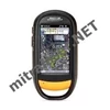
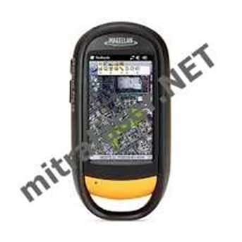
GPS Magellan eXplorist Pro10 GNSS Driver + EZSurv
Ruggedized and waterproof for extreme conditions
Integrated digital camera, speaker and microphone
Bluetooth wireless connectivity to Bluetooth-enabled devices
Expandable Micro SDHC Card memory storage
EZSurv Post-processing enables greater accuracy and reliability
GNSS Driver for ArcPad allow to seamlessly record GPS observables needed for post-processing while using ESRI ArcPad
The Magellan eXplorist Pro 10 keeps your GIS database accurate and up-to-date. With just one system, large amounts of data can be mapped virtually effortlessly in a minimal amount of time. The small, lightweight, yet rugged eXplorist Pro 10 is the simple solution to your biggest GIS mobile application challenges. With a powerful 533MHz processor, 128MB RAM, and 4GB of onboard storage, the high-performance, handheld eXplorist Pro 10 provides all the power needed to work with maps and large-data sets away from the office. Its Windows Mobile® v6.5 operating system allows you to choose a software solution designed specifically for your needs. The unit’ s built-in Bluetooth wireless technology makes it easy to receive background map data off the Internet using a Bluetooth-enabled cell phone. It also can be connected to other Bluetooth-enabled devices, such as laser rangefinders and barcode scanners, for convenient cable-free solutions. Supply your mobile workforce with the durable, compact eXplorist Pro 10 that incorporates functional features such as photo, video and voice note capture and a high-yield GPS receiver with 3 to 5 meters real-time positioning accuracy ( 1 to 3 meter post-processed accuracy) . The handheld eXplorist Pro 10 is the affordable way to maximize mobile GIS productivity. EZTag CE allows you to easily collect geospatial data, including points, lines and polygons, along with their specific attributes. Ready-to-use without programming, the EZTag CE data dictionary editor manages simple and relational data models. Users can customize the data capture properties to match their own office database structure.
Tampilkan Lebih Banyak